

The sixth Workshop: 2016 Japan-New Zealand-Taiwan Seismic Hazard Assessment
Field trip guide
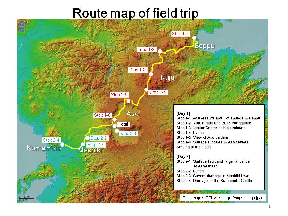
In order to further understand geological setting and seismic back-ground of PSHA in Japan, two days field trip has been arranged crossed Kyushu regions. We selected following stops to let participants to have experiences of Kumamoto earthquake, co-seismic faults, and the Japan Median Tectonic Line in Kyushu.
Here is a guide map with some explanations.
November 3rd (Day 1)
-
Stop 1-1: "Umi-jigoku" hot spring
There are several normal faults with strike of E-W in Beppu, where some of hot springs are located on. The local active fault trace map and related parameters will be explained at the famous hot springs, so-called "Umi-jigoku (Sea Hell)", and “Oniishibozu-Jigoku (Oniishi shaven head hell)”. -
Stop 1-2: Yufuin fault and 2016 earthquake
An active fault, Yufuin fault, is located along the southern margin of Yufuin basin. Just 32 seconds after the main-shock of the 2016 Mj=7.3 Kumamoto Earthquake, an Mj=5.7 earthquake was triggered on this fault and consequentially severe damages occurred in Yufuin and Beppu. The waveforms and crustal movement data of this earthquake will be explained as well as the information of Yufuin fault. -
Stop 1-3: Visitor Center at Kuju volcano
We will have short stop at the foot of Kuju Volcano, which is an active volcano located in the Beppu–Shimabara Graben and small-scale eruptions released ashes during 1995 to 1996. - Stop 1-4: Lunch
-
Stop 1-5: View of Aso caldera
We will have wide scenery of Aso caldera, where the surface ruptures and damages of road and bridges were occurred caused by the 2016 Kumamoto Earthquake. Current caldera was formed by a huge eruption ca. 90,000 years ago, which released huge pyroclastic flows, so-called as "Aso-4". -
Stop 1-6: Surface ruptures in Aso caldera
Several grabens were produced in the northwestern area of Aso caldera. They are considered as not surface faulting but ruptures related to lateral spreading, although their distribution are consisted with location of extension of the Futagawa fault.
Arriving at the Hotel
November 4th (Day 2)
-
Stop 2-1: Surface fault and large landslide at Aso-Ohashi
Surface faulting occurred by the main-shock of the 2016 Kumamoto Earthquake at the most western part of Aso caldera. This area is located on the extension of Futagawa fault even though no tectonic landform was recognized before the earthquake. Large landslide occurred on the caldera wall and its debris broke the Aso-Ohashi bridge. - Stop 2-2: Lunch
-
Stop 2-3: Severe damage in Mashiki town
Downtown of Mashiki town had severe damages caused by both of the foreshock and the main-shock of the 2016 Kumamoto Earthquake. Seismograph at this town recorded JMA seismic intensity 7 twice. Severe damage zone was located along the extension of Kiyama fault on the lower fluvial terrace, which consists of soft sediments near the ground surface. -
Stop 2-4: Damage of the Kumamoto Castle
Kumamoto Castle was founded at the beginning of the 17 centuries by Kato Kiyomasa. The present Castle was re-built in 1960. This castle had severe damages by the 2016 Kumamoto Earthquake. Its stonewalls were also damaged by former earthquakes in 1858 and 1889.
Prepared by Takashi Azuma (AIST), Ken Xiansheng Hao, Shinich Kawai (NIED)