What are the National Seismic Hazard Maps for Japan?
The National Seismic Hazard Maps for Japan is prepared by a governmental organization, the Headquarters for Earthquake Research Promotion (HERP) to estimate strong motions caused by earthquakes that could occur in Japan in the future and show the estimated results on the maps. The National Seismic Hazard Maps for Japan consist of two types of maps different in nature: the Probabilistic Seismic Hazard Maps (PSHM) that combine long-term probabilistic evaluations of earthquake occurrence and strong motion evaluation, and the Seismic Hazard Maps for Specified Seismic Source Faults (also referred to as Scenario Earthquake Shaking Maps (SESM) in J-SHIS), which are based on strong motion evaluation for scenarios assumed for specific earthquakes.
Probabilistic Seismic Hazard Maps (PSHM)
PSHM are prepared by calculating the probability that a given site will experience ground motion intensity exceeding a certain value within a target period. For this calculation, evaluation is conducted by using a probabilistic approach on the site of occurrence, probability of occurrence, and magnitude of all earthquakes that could occur in and around Japan, and the intensity of the ground motions caused by those earthquakes are evaluated with variance. Seismic hazard evaluation is conducted for each site and by fixing any two parameters of the ground motion intensity, period, and probability, the value of the remaining parameter is obtained. PSHM show the distribution of such values.
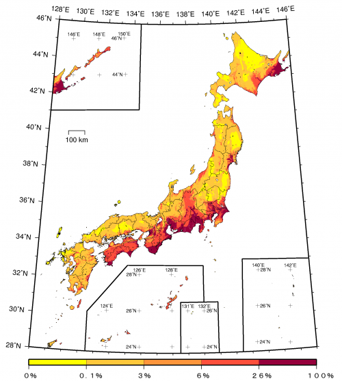
There are various types of maps in PSHM. One representative is a map showing the probability that each site will be affected by an earthquake of seismic intensity 6 lower or more within 30 years.

Exceedance probability within 30 years considering all earthquakes (JMA seismic intensity: 6 Lower or more; average case; period starting Jan. 2010)
Scenario Earthquake Shaking Maps (SESM)
Meanwhile, for earthquakes that occur at specified fault zones, SESM are designed to estimate the ground motion intensity around the faults at the occurrence of the earthquake and show the results on the maps. SESM have enabled accurate estimation of near-fault strong motions by simulating seismic wave propagation considering complex subsurface structure based on a physics model of fault rupture. Although the estimation methods used here are very complicated, the strong ground motion estimation method (Recipe) for earthquakes with specified source faults has been developed as a result of standardizing the methods.

